
It was an “alpine start.” On March 11, my alarm went off at 12:45 a.m. I was in my car by 1 a.m., driving three and 1/2 hours from my home in Connecticut to the White Mountains of New Hampshire in a bid for a one-day, 20-mile hike across the tallest peaks in the northeast.
I’d been monitoring the weather for weeks, looking for a break in the notorious wind and cold atop Mt. Washington so I could attempt my first winter Presidential Traverse, considered “New England’s single biggest mountaineering challenge,” “the most coveted–and riskiest–mountaineering feat in the Northeast,” and “the quintessential multi-day mountaineering objective in the Northeast.”
The previous day, I’d been surprised to see a high summits prediction of 25-35 mph winds and 15-25 F temps, with decent visibility and little precipitation. Given wind speeds had been more than 100 mph for several days, and that a snowstorm was predicted for the coming days, it was a rare window of good weather for the traverse — far better conditions than when 32-year-old Kate Matrosova froze to death five years earlier when attempting the same hike.
I carried no GPS, SPOT, or cellphone, because I own none, so I needed to be extra cautious to not get in over my head. At least there was no danger of catching coronavirus.
By 4:30 a.m. I was at Appalachia Trailhead on Rt. 2 in Randolph. The temp was 27 F and the wind was negligible. By the light of my headlamp, I began snowshoeing up Valley Way Trail wearing tights and soft shell snow pants, a long-sleeve shirt and a windbreaker, and a pack containing: a down jacket, a heavy parka, snacks, six liters of water, extra gloves, socks, and balaclavas, three extra flashlights, and a sleeping pad in case I needed to rest. (Maybe I overpacked on flashlights.) Within minutes I was so warm I took off my hat and gloves.
I reached Madison Spring Hut at 6:30 a.m. and dropped my bag so I wouldn’t have to carry it up and down the several hundred feet to the top of Mt. Madison. I summited Madison at 7 a.m. as the sun rose. I had last stood there six years earlier when doing a one-day Presidential Traverse in summer, which took 12 hours. I was aiming to finish this solo winter traverse in under 10 hours.


Back at Madison Spring Hut, I switched into crampons and took a long swig of water. A light snow was falling but visibility was still 10-20 miles with a steady breeze. I took the Star Lake Trail to Mt. Adams, reaching its summit at 8 a.m. Conditions were far better than when, seven years earlier, I’d been on Adams in a blizzard and lost the trail amid white-out conditions.
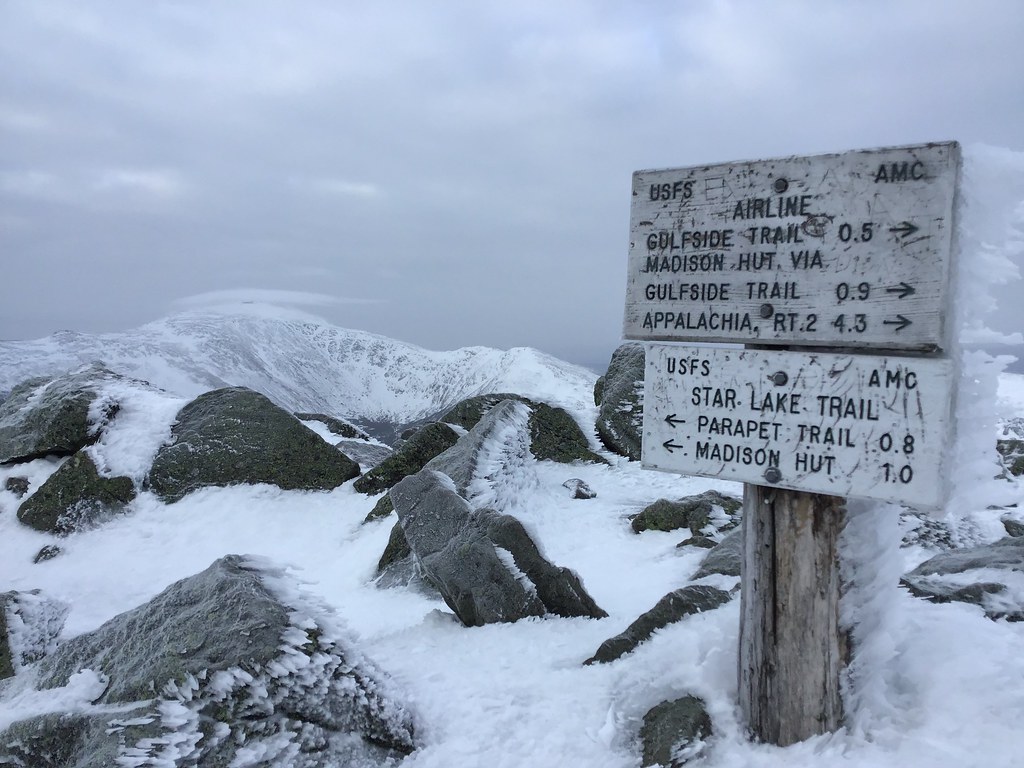
From Adams, I took the Gulfside Trail through Edmonds Col to Mt. Jefferson, which I reached at 9 a.m.


I diverged from the Gulfside Trail to go over Mt. Clay (5,533 feet), summiting it at 9:40 a.m., then got back on Gulfside to Mt. Washington (6,288 feet), topping out at 10:30 a.m. By now I’d covered 10.6 miles and gained a cumulative 7,300 feet in elevation, with only 1,000 feet more to gain over the remaining nine miles of the traverse. It was reassuring to be more than halfway done.

At Washington’s summit I caught up with another hiker named Graham (the second person I’d seen in five hours) who was also doing a solo traverse. Together we sped down the Crawford Path to the Lakes of the Clouds Hut and had a 15-minute lunch break. For the remainder of the traverse we had a friendly competition for who could finish first, each of us jogging whenever possible across the snow and ice. We seemed to be the only two people doing the full traverse, though I counted four other solo hikers going up and down Mt. Washington.
I summited Mt. Monroe (5,372 feet) at 11:30 a.m., Mt. Eisenhower (4,750 feet) at 12:40 p.m., and Mt. Pierce (4,312 feet) at 1:15 p.m., where I took another 15-minute break for water and food. A half-dozen teenagers were milling atop Pierce on a wilderness education course.


I jogged the remaining 3.6 miles down the Crawford Path to Rt. 302 in Crawford Notch, finishing at 2:30 p.m. My total time on trail was 9 hours and 36 minutes for the 20-mile traverse.
Now I had to figure out how to get back to my car, 35 miles away. I saw Graham standing by a guardrail. As I walked toward him, I put up my thumb to a passing SUV, hoping that I might hitchhike (rather than call a tax service, which would cost at least $85). The SUV doubled back and offered Graham and I a ride halfway back to the trailhead. I got to sit in the backseat with a cuddly Bernese Mountain Dog.

About 10 miles down the road, I thumbed five passing cars — none stopped. Then I waved a $20 at the next passing car — she immediately stopped and gave us a ride to Appalachia Trailhead. Turned out, she was a Keene State student home on a prolonged spring break because of the coronavirus shutdown. So much for avoiding contagion risk.
From the trailhead, it was a four-hour drive home to Connecticut. According to the Mount Washington Observatory, the day’s temperature ranged from 14F to 22F, the average wind speed was 26.7 mph, the peak gust was 48 mph, and there was 0.2 inches of snowfall. It was probably one of the best days all winter for the Presidential Traverse. (I’ve seen worse weather on Washington in August.)
